
Recent blog posts
- Ireland Backs South Africa Genocide case Against Israel
- St Patrick's Day Message from Celtic Congress Cornwall
- DELARGY: THE 1954 CONGRESS RECORDINGS
- Israel Loses in the Court of Public Opinion says Irish MEP
- KUNO MEYER - PRAISE INDEED!
- NORSE-MANX LINKS: THE WARTIME PRINCE OLAV VISITS
- ENDURING MYSTERY OF THE MAN WHO SPOKE HIS MIND
- MORRISON CONTEMPORARY MADE HER MARK
- ‘NOTHING GAINED WITHOUT FANATICISM’
- Illiam Dhone Commemoration 2024
Visit us on Facebook
And on Twitter
And on Youtube
Project in Dundee Reveals How Scottish Landscape Transformed by Last Ice Age
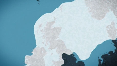
In the history of the Earth there have been at least five significant ice ages. Approximately twelve epochs of glacial expansion have occurred in the past one million years. The last ice age known as the Last Glacial Period (LGP) ended about 20,000 years ago. Glaciers extended over much of northern Europe and covered many of what we now call the Celtic nations.
An ice age causes massive changes to the Earth’s surface with glaciers reshaping the landscape. These enormous ice movements picking up rocks and soil and eroding hills. Dramatic drops in sea level also resulted in rivers carving deep valleys and producing enormous inland lakes. Retreating during warmer periods, the glaciers leave behind scattered ridges of sediment and fill basins with melted water to create new lakes and lochs.
Now a new project is underway in Scotland to look at the impact that the ice age had on the landscape of the area known as Tayside (Scottish Gaelic: Taobh Tatha). The project has revealed this in a new video visualisation and has been created by glaciologist Max Van Wyk de Vries and animation lecturer Kieran Duncan. The visualisation shows that the whole of Scotland lay beneath a massive ice sheet that extended far into the North Sea. It includes an illustration of how the area that is now Dundee (Scottish Gaelic: Dùn Dè or Dùn Dèagh) was covered by more than 1km of solid ice. The video will feature on a dedicated website and also be shown as part of an exhibition at the Dundee's Art Gallery and Museum (The McManus).
Images: Above Scotland completely under ice sheet during last Ice Age and below Dundee as it is now with illustration of !km of Ice that once covered the city. Both images by Kieran Duncan and courtesy of BBC Scotland.

Disclaimer:
This blog is provided for general informational purposes only. The opinions expressed here are the author's alone and not necessarily those of Transceltic.com.


