Celtic Recipes

Powis Castle - Castell Powis

Powis Castle image courtesy of BBC

Castell Powis (Powis Castle). Originally a motte and bailey castle stood on the site of what is now a residence  associated with Robert Clive (Clive of India) through his son's marriage. The location of the original castle mound is close to the present house. The later dwelling saw action during the English Civil War and is now managed by the National Trust. The site is located about one mile south of Welshpool off the A483.

Castell Caereinion

This is a mid-twelfth century Welsh motte and bailey castle. The mote now remains in the corner of the churchyard and the site is located at Castle Caerinion on the B4385 off the A458 west of Welshpool.

Y Breiddin Hillfort

Rodney's Pillar on top of Breidden Hill. Llandreinio Bridge and Rodney's Pillar is a watercolour dated 1794 by John Ingleby (1749 - 1808)

This is a large hillfort site occupied through the Bronze and Iron Ages into the Roman period. It is located on a ridge and the remains of the defensive ditch, stone inner bank and outer bank can be seen. Excavations have revealed timber roundhouses and other buildings existed within the fort. The site is located off the A483 and A458 northeast of Welshpool, past Trewern towards Rodneys Column.

Carreghoffa Castle - Castel Carreghoffa

This castle was built at the beginning of the twelfth century and swopped hands between the English and Welsh several times. It was finally destroyed by the Welsh in the early-mid thirteenth century and the remains seen today are significant earth works. The site is southwest of Oswestry at Llanyblodwel off the A495.

Tyfos - Ring of Tyfos

This site is close to Moel Ty Uchaf and is made up of fourteen low stones in a circle. It is about two miles northwest of Llandrillo southwest of Llagollen.

Moel Ty Uchaf

This site is made up of 41 standing stones and surround a cist. The site gives commanding views of the valley below and is situated off the B4401 between Corwen and Llandrillo southwest of Llagollen.

Rhos Y Beddau

The site is located further on along the path leading up to Pystell Rheadr Waterfall. A long avenue leads to the stone circle which is at the head of the valley. The site is located along the B4396 past Llhanrhaeadr-ym-Monchant southwest of Oswestry. Maps are required to find this location.

Caer Drewyn

Caer Drewyn Hillfort image courtesy Llangollen website

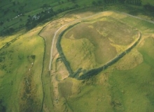
Caer Drewyn Hillfort dates to the Iron Age 700BC - 50AD. It has commanding views and shows evidence of having been occupied over different periods with the remains of a number of defended closures, banks, stone ramparts, huts and ditches. The site is west on the A5 from Llangollen to Corwen where the B5437 takes you to a junction of the A5104 where a right turn leads to a signposted footpath to the Fort.

Chirk Castle - Castell y Waun

Chirk Castle is located off the A5 southeast of Llagollen. Constructed in the late thirteenth and early fourteenth century. It was refurbished in the late sixteenth century and rebuilt following damage in the English Civil War. Offa's Dyke runs through the park that surrounds the castle.

Castell Dinas Bran

A Welsh castle was built on the site of an earlier Iron Age Fort and is associated with Arthurian legend. The remains today are from a later date and in 1277 the castle was taken and destroyed by the English and not rebuilt. It is located above Llangollen giving excellent views.

Pages