Places to visit

Polruan - Porthruan

Polruan - Porthruan

Polruan (Porthruan) is a small fishing village west along the coast from Lansallos. It is also known for boat building and is surrounded on three sides by the Pont Creek to the north, the River Fowey to the south and the English Channel. The ruin of the eighth century St Saviour's church stands on the hill above Polruan. The village also has a blockhouse fortification dating back to the fourteenth century which is one of a pair that guards the entrance to the river Fowey. Polruan can be reached car and a local bus service via Looe and Polperro. The Polruan ferry crosses regularly year round to and from Fowey. There is also a ferry to Fowey from the neighbouring village of Boddinick. When the car ferry from Bodinnick is not running, Fowey can be reached by car via a journey via Lostwithial.

Bodinnick

Bodinnick is a fishing village on the east bank of the River Fowey opposite Fowey and about four miles from Portruan. There is a ferry service between Fowey and Bodinnick. Daphne du Maurier wrote many of her novels when living at "Ferryside" on the river bank at Bodinnick. Historically the village is an important ferry terminal for people travelling from Fowey, with the "Old Ferry Inn" close to the bank of the river. Scenic walks can be taken along the Polruan River on the route known as the Hall Walk. This walk takes you around Pont Creek which is joined to an estuary at Pelene Point which leads to the chapel of St Wyllow.

Fowey - Fowidh

Fowey - Fowidh

Fowey (Fowidh) is a small town, dating from medieval times, at the mouth of the River Fowey with ferry crossings to Polruan (foot) and Bodinnick (Car). It's natural harbour gave rise to the development of trade and seen as of strategic importance. Two blockhouses were built for defence at either side of the harbour entrance and a small castle built in about 1540 on St Catherines Point. The town's strategic importance is demonstrated by the attacks sustained by French and Dutch in 1457 and 1667 respectively. The area was the site of military activity in the Civil War with Charles 1 visiting the area in engagements with the Parliamentary forces of the Earl of Essex. To the south of Fowey is a sandy beach to the south of Fowey between the medieval part of the town and St Catherine's Castle.

St Catherine's Castle

St Catherine's Castle

St Catherine's Castle is situated on the headland known of St Catherine's Point at the entrance to the River Fowey estuary. Possibly of importance since prehistory. A medieval chapel to the north of St Catherine's Castle was replaced in the 19th century by a granite arched mausoleum commemorating the Rashleigh family.

In the aftermath of the reformation Henry VIII commissioned a two storey blockhouse on the site between 1538 and 1540. This added to the harbour defences in response to increased military threat from Spain and France.

Golant - Goelnans

Golant/Goelnans is a village situated on the west bank of the River Fowey about two miles north of Fowey and seven miles east of St Austell. It was in this area that battles took place between Royalist and Parliamentary forces in the English Civil War. Golant church is dedicated to St Sampson.

Castle Dore

Castle Dore is an Iron Age settlement first occupied between the fourth and first centuries BC. Returning west from Golant to the B3296 and turn north for a short distance and the site is on the right side of the road. No formal right of way to the site is in place and the owner's permission should be sought. The site can be reached by parking in a lay-by south of the site and the monument is reached by a short walk back along the B3269 road to a gateway on the west side of the fort.

Lostwithiel - Lostwydhyel

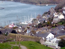
Continue north from Golant to Lostwithiel/Lostwydhyel. This is a small town in at the head of the estuary of the River Fowey and is on the A290 toward St Austell and Truro. Lostwithiel Railway Station, which is just across the medieval bridge to the south of the town, is on the Cornish Main Line between Plymouth and Penzance.

Amongst Lostwithiel's most notable buildings is St Bartholomew's Church which is a Grade 1 listed building. It is mainly fourteenth century and also includes a tower from the thirteenth century, with a spire added in the early fourteenth century.

Respryn Bridge

Respryn Bridge is a medieval bridge across the River Fowey in Lanhydrock Parish. It has five arches. The bridge replaced an earlier thirteenth century one with the central arch dating back to the fifteenth century. The other arches are round and the two on the west are relatively modern. There are low parapets with granite coping and triangular stone cutwaters with refuges. King Charles was said to have ridden over the bridge in 1644 during the Civil War. The bridge is north along the B3268 from Lostwithiel and west of Lanydrock House towards Cutmadoc.

Helman Tor

Returning south from Respryn Bridge Helman Tor is a Neolithic site between Bodmin and Lostwithiel southwest of Sweethouse. The tor is at the northern end of a north-south granite ridge. Archaeological surveys have identified a series of low walls and levelled terraces on the tor. Within the enclosure are a number of level platforms thought to be house sites. Finds from the hilltop include greenstone axes, flint tools, stone querns and gabbroic pottery which confirm the Neolithic date for the construction and occupation of the tor.

Tywardreath - Chi war Dreth

Tywardreath/Chi war Dreth is a small village to the east of St Blazey and the A390 and is about 3 miles north west of Fowey. It was the site of a priory that was built at about the time of the conquest and was dissolved in 1540. The church of St Andrew's in Tywardreath was dedicated in 1343 but was heavily rebuilt in 1880.

Pages

Subscribe to Places to visit