Places to visit

Trethevy Quoit

Trethevy Quoit is thought to be the best preserved quoit in Cornwall. Four overlapping granite slabs form the sides of the chamber with lateral stones at the back and front. The stone at the back leans inwards and a large capstone rests on these uprights at an acute angle. A round hole has been made through the top corner of the capstone. A small antechamber is at the front of the monument with two upright stones remaining. Around the quoit is a stony cairn. Sites of this type are thought to have been constructed in the early and middle Neolithic period between 3700-3300 BC. Although no bones have been found, they were used over long periods as communal tombs. Quoits were also used for cremations placed in urns in the Bronze age.

The Hurlers Stone Circles

The Hurlers Stone Circles

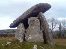
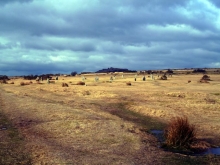
Travel north from Trevethy Quiot to Darite, The south-facing slope of Minions Moor is the location of the three stone circles known as the Hurlers (Cornish: An Hurlysi). The centres of the circles point towards the ridge to the north, with Rillaton Barrow on the horizon and the summit of Stowe's Hill. Dating to the early Bronze Age, the Hurlers lie in a landscape of stone circles, stone rows, standing stones, cists and cairns. The alignments of the Hurlers, acknowledging surrounding tors and barrows suggest they may have been part of a significant processional route.

Stowe's Pound

Stowe's Pound is on the top of a granite ridge north of Minions village on the south-eastern of Bodmin Moor. The hill is the site of the Cheesewring and of Cheesewring Quarry. The hill is at the edge of the moorland, which overlooks Rillaton Moor and Witheybrook Marsh, to the south and west. To the east are the upper reaches of the River Lynher. The summit of the ridge is enclosed by stone-walled enclosures. A small enclosure, encircles the tors at the southern end of the hill. A bigger subsidiary enclosure, encloses the summit ridge of the hill.

Craddock Moor Stone Circle

About a kilometre to the west-north-west of The Hurlers is the remains of the Craddock Moor stone circle. This consists of sixteen or seventeen fallen stones. Quarrying that has taken place in the area make it difficult to ascertain the original design and of the site. The Craddock Moor circle stones appear to be graded in size with alignments seemingly linked to other sites in the area.

Set on open common land a mile to the north-west of Minions, there is full access to and around the monument.

King Doniert's Stone - Men Myghtern Doniert

King Doniert's Stone - Men Myghtern Doniert

Return southwest along the road from Minions. King Doniert's Stone (Men Myghtern Doniert), also called as The Donier Stone, is one of two ancient carved stones which stand in an enclosure beside the road linking the A38 to Minions and Upton Cross. It is to the south-eastern side of Bodmin Moor. The two stones are parts of early medieval crosses, possibly dating to the late ninth century.

Duloe Stone Circle

Take the B3254 from Liskeard south towards Duloe village. This is the smallest stone circle in Cornwall. It is situated on a flat ridge top, flanked half a mile on either side by deep valleys containing the Looe and West Looe rivers. The circle is made up of eight large and white quartz blocks set in a pattern of alternating large and small stones. During excavation, a Bronze Age ribbon handled urn was uncovered, which contained cremated human bone.

The circle can be reached via a signposted track between two houses in Higher Stonetown to the southwest.

Looe - Logh

Looe - Logh

South along the B3254 from Duloe until it joins the A374 and travel south. Looe (Logh) a fishing port and coastal town and is actually made up of the two towns of East Looes and West Looe in which are linked by a bridge across the River Looe. The towns are some seven miles south of Liskeard along the valley of the River Looe which flows to the sea by a sandy beach. Liskeard Railway Station is the junction for the Looe Valley Line with the Station in Looe being just to the north of the bridge. To the west is St George's Island (Looe Island). Archaeological information points to the area around Looe being inhabited around 1000BC. Looe now continues to be a fishing town although tourism now predominates. There is a thriving tourist industry in the area with numerous related shopping and entertainment facilities.

Talland

Talland, west along the coast from Looe, is a hamlet between Looe and Polpero that is made up consists of a church, the old vicarage and some houses. Nearby is Talland Bay with the two sheltered shingle beaches of Talland Sand and Rotterdam Beach. The beaches in Talland Bay can be accessed, by a car park and there is a café.

Polperro - Porthpyra

Polperro - Porthpyra

Continue west along the coast to Polperro (Porthpyra) which is a village and fishing port situated on the River Pol. It four miles west of Looe and is a fishing harbour surrounded by old fishermen's houses. Tourism is now Polperro's main industry and the village can be reached by road and the train from Looe Railway Station. Visitors cannot take their cars into the village and there is a car park just north of the village with about a half mile walk to the harbour. Other forms of transport are made available to get to the harbour. The South West Coast Path (stretching from Dorset to Somerset) goes through the village from Talland Bay in the east and west towards Fowey, Llansallos Beach, Lantavit Bay and Lantic Bay. Within Polperro are a number of restaurants.

Lansallos - Lannsalwys

Lansallos - Lannsalwys

Lansallos (Lannsalwys) is coastal village between Polperro and Polruan and is passes by the scenic South West Coastal Path. The village takes it's name form a monastery dedicated to St Salwys and within the village is the parish church dedicated to St Ildierna.

Pages

Subscribe to Places to visit