Recent blog posts
- Reih Bleeaney Vanannan Award 2025 - Isle of Man’s Highest Cultural Honour
- Who Was St Patrick?
- 'The Deer's Cry' Illustrations by Archibald Knox
- Winter Solstice at Newgrange Ancient Passage Tomb
- Israel to close Dublin embassy as Ireland continues stand for peace in Gaza
- Ireland will act on International Criminal Court Warrant to arrest Israeli Prime Minister Benjamin Netanyahu
- ICC issues arrest warrants for Israeli Prime Minister Benjamin Netanyahu and former Defence Minister Yoav Gallant
- Wooden Celtic 2,600-year-old burial chamber uncovered in southern Germany
- Largest, most comprehensive, Archibald Knox exhibition and events ever held in the world
- Pope Calls for Immediate Ceasefire in Gaza and Lebanon
Visit us on Facebook
And on Twitter
And on Youtube
Europe's Oldest 3D Map from Bronze Age found in Brittany
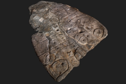
A Bronze Age slab found in Brittany (Breton: Breizh) is thought to be Europe’s oldest 3D map. It is believed to date from the early bronze age between 2150BC and 1600BC. Researchers from the French National Institute for Preventive Archaeological Research (Inrap), Bournemouth University, the CNRS and the Université de Bretagne Occidentale (UBO – University of Western Brittany) examined the carved slab from Saint-Bélec (Leuhan, Finistère Department). The results of which have been published in the French journal Bulletin de la Société préhistorique française. They have identified it as the oldest cartographical representation of a known territory in Europe and possibly a marker of the political power of a principality of the early Bronze Age.
The 2.2-metre by 1.53-metre (5ft by 6.5ft) stone known as the Saint-Bélec Slab, was actually first discovered in 1900 in a prehistoric burial ground in Finistère (Breton: Penn-ar-Bed), western Brittany, by local archaeologist Paul du Chatellier. For a number of years it was lost but rediscovered in the cellar of Château de Kernuz in 2014. It is though to show an area of western Brittany. The broken slab, early Bronze Age (2150-1600 BC), when originally found had been re-used in the burial of the Saint-Bélec towards the end of the early Bronze Age (c. 1900-1640 BC). At the time, the slab formed one of the walls of a stone-cist, a small stone coffin-like box used to hold the bodies of the dead. Its engraved face was turned towards the inside of the tomb, but its ends were hidden.
The secrets of the stone are being revealed by the research team, including BU Post-Doctoral Researcher Dr Clément Nicolas. This began to to be achieved by carrying out high-resolution 3D surveys and photogrammetry of the slab in 2017, recording the surface of the slab and its engravings. An examination of the engraved surface shows that the slab’s topography was purposely 3D-shaped to represent the valley of the River Odet, whilst several lines appear to depict the river network. The results of the research highlights the cartographic knowledge of prehistoric societies.
The image above of the Saint-Bélec Slab is courtesy of Bournemouth University with a link to their article here.
Disclaimer:
This blog is provided for general informational purposes only. The opinions expressed here are the author's alone and not necessarily those of Transceltic.com.


