
Recent blog posts
- Ireland Backs South Africa Genocide case Against Israel
- St Patrick's Day Message from Celtic Congress Cornwall
- DELARGY: THE 1954 CONGRESS RECORDINGS
- Israel Loses in the Court of Public Opinion says Irish MEP
- KUNO MEYER - PRAISE INDEED!
- NORSE-MANX LINKS: THE WARTIME PRINCE OLAV VISITS
- ENDURING MYSTERY OF THE MAN WHO SPOKE HIS MIND
- MORRISON CONTEMPORARY MADE HER MARK
- ‘NOTHING GAINED WITHOUT FANATICISM’
- Illiam Dhone Commemoration 2024
Visit us on Facebook
And on Twitter
And on Youtube
Staigue Stone Fort
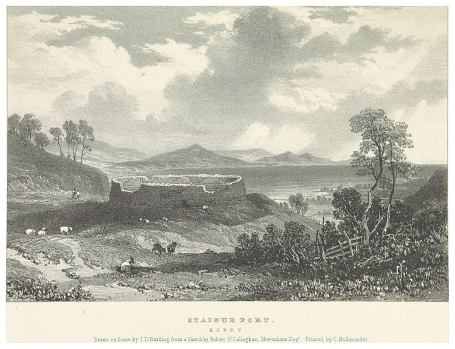
Staigue Stone Fort (Irish: an Stéig or Caiseal Stéig is a ruined stone fort with walls reaching about five and half metres in height in places and four meters thick at it's base. It encloses an area of about 27 metres in diameter and surrounded by a wide ditch. Within the structure are passages and stairways. It dates back to the Iron Age between 300AD and 400AD. The site is located on the Iveragh Peninsula (Irish: Uíbh Ráthach) west from Kenmare and north of the N70 at the top of a valley three miles west of Sneem (Irish: An tSnaidhm), close to a minor road north of Castlecove, County Kerry (Irish: Cuan an Chaisleáin, Contae Chiarraí).
Image: Staigue Fort sketch, by Robert O’Callaghan. Newenham, from Picturesque Views of the Antiquities of Ireland, 1830.
Celtic nation:
- Ireland
Itinerary:
- Ireland Munster west
Place type:
- Ancient site


